Natural complexes and natural areas. Concept of a natural complex Describe a small natural complex taking into account all components
The concept of a natural complex
The main object of study of modern physical geography is the geographical shell of our planet as a complex material system. It is heterogeneous in both vertical and horizontal directions. In the horizontal, i.e. spatially, the geographic envelope is divided into separate natural complexes (synonyms: natural-territorial complexes, geosystems, geographic landscapes).
A natural complex is a territory that is homogeneous in origin, history of geological development and modern composition of specific natural components. It has a single geological foundation, the same type and amount of surface and groundwater, a uniform soil and vegetation cover and a single biocenosis (a combination of microorganisms and characteristic animals). In a natural complex, the interaction and metabolism between its components are also of the same type. The interaction of components ultimately leads to the formation of specific natural complexes.
The level of interaction of components within a natural complex is determined primarily by the amount and rhythms of solar energy (solar radiation). Knowing the quantitative expression of the energy potential of a natural complex and its rhythm, modern geographers can determine the annual productivity of its natural resources and the optimal timing of their renewability. This allows us to objectively predict the use of natural resources of natural-territorial complexes (NTC) in the interests of human economic activity.
Currently, most of the natural complexes of the Earth have been changed to one degree or another by man, or even re-created by him on a natural basis. For example, oases in the desert, reservoirs, agricultural plantations. Such natural complexes are called anthropogenic. According to their purpose, anthropogenic complexes can be industrial, agricultural, urban, etc. According to the degree of change by human economic activity - in comparison with the original natural state, they are divided into slightly changed, changed and strongly changed.
Natural complexes can be of different sizes - of different ranks, as scientists say. The largest natural complex is the geographical envelope of the Earth. Continents and oceans are natural complexes of the next rank. Within the continents, physical-geographical countries are distinguished - natural complexes of the third level. Such, for example, as the East European Plain, the Ural Mountains, the Amazon Lowland, the Sahara Desert and others. Well-known natural zones can serve as examples of natural complexes: tundra, taiga, temperate forests, steppes, deserts, etc. The smallest natural complexes (terrains, tracts, fauna) occupy limited territories. These are hilly ridges, individual hills, their slopes; or a low-lying river valley and its individual sections: bed, floodplain, above-floodplain terraces. It is interesting that the smaller the natural complex, the more homogeneous its natural conditions. However, even natural complexes of significant size retain the homogeneity of natural components and basic physical-geographical processes. Thus, the nature of Australia is not at all similar to the nature of North America, the Amazonian lowland is noticeably different from the Andes adjacent to the west, an experienced geographer-researcher will not confuse the Karakum (temperate zone deserts) with the Sahara (tropical deserts), etc.
Thus, the entire geographical envelope of our planet consists of a complex mosaic of natural complexes of different ranks. Natural complexes formed on land are now called natural-territorial complexes (NTC); formed in the ocean and other body of water (lake, river) - natural aquatic (NAC); natural-anthropogenic landscapes (NAL) are created by human economic activity on a natural basis.
Geographical envelope - the largest natural complex
The geographic envelope is a continuous and integral shell of the Earth, which includes, in a vertical section, the upper part of the earth's crust (lithosphere), the lower atmosphere, the entire hydrosphere and the entire biosphere of our planet. What unites, at first glance, the heterogeneous components of the natural environment into a single material system? It is within the geographic envelope that a continuous exchange of matter and energy occurs, a complex interaction between the indicated component shells of the Earth.
The boundaries of the geographical envelope are still not clearly defined. Scientists usually take the ozone screen in the atmosphere as its upper limit, beyond which life on our planet does not extend. The lower boundary is most often drawn in the lithosphere at depths of no more than 1000 m. This is the upper part of the earth’s crust, which was formed under the strong combined influence of the atmosphere, hydrosphere and living organisms. The entire thickness of the waters of the World Ocean is inhabited, therefore, if we talk about the lower boundary of the geographical envelope in the ocean, then it should be drawn along the ocean floor. In general, the geographic shell of our planet has a total thickness of about 30 km.
As we can see, the geographical envelope coincides in volume and territorially with the distribution of living organisms on Earth. However, there is still no single point of view regarding the relationship between the biosphere and the geographical envelope. Some scientists believe that the concepts of “geographical envelope” and “biosphere” are very close, even identical, and these terms are synonyms. Other researchers consider the biosphere only as a certain stage in the development of the geographic envelope. In this case, three stages are distinguished in the history of the development of the geographical envelope: prebiogenic, biogenic and anthropogenic (modern). The biosphere, according to this point of view, corresponds to the biogenic stage of the development of our planet. According to others, the terms “geographical envelope” and “biosphere” are not identical, since they reflect different qualitative essences. The concept of “biosphere” focuses on the active and determining role of living matter in the development of the geographical envelope.
Which point of view should you prefer? It should be borne in mind that the geographic envelope is characterized by a number of specific features. It is distinguished, first of all, by the great diversity of material composition and types of energy characteristic of all component shells - the lithosphere, atmosphere, hydrosphere and biosphere. Through general (global) cycles of matter and energy, they are united into an integral material system. To understand the patterns of development of this unified system is one of the most important tasks of modern geographical science.
Thus, the integrity of the geographical envelope is the most important pattern, on the knowledge of which the theory and practice of modern environmental management is based. Taking this pattern into account makes it possible to foresee possible changes in the nature of the Earth (a change in one of the components of the geographic envelope will necessarily cause a change in the others); give a geographical forecast of the possible results of human impact on nature; carry out a geographical examination of various projects related to the economic use of certain territories.
The geographic envelope is also characterized by another characteristic pattern - the rhythm of development, i.e. recurrence of certain phenomena over time. In the nature of the Earth, rhythms of different durations have been identified - daily and annual, intra-century and super-secular rhythms. The daily rhythm, as is known, is determined by the rotation of the Earth around its axis. The daily rhythm is manifested in changes in temperature, air pressure and humidity, cloudiness, and wind strength; in the phenomena of ebb and flow in the seas and oceans, the circulation of breezes, the processes of photosynthesis in plants, the daily biorhythms of animals and humans.
The annual rhythm is the result of the movement of the Earth in its orbit around the Sun. These are the change of seasons, changes in the intensity of soil formation and destruction of rocks, seasonal features in the development of vegetation and human economic activity. It is interesting that different landscapes of the planet have different daily and annual rhythms. Thus, the annual rhythm is best expressed in temperate latitudes and very weakly in the equatorial belt.
Of great practical interest is the study of longer rhythms: 11-12 years, 22-23 years, 80-90 years, 1850 years and longer, but, unfortunately, they are still less studied than the daily and annual rhythms.
Natural zones of the globe, their brief characteristics
The great Russian scientist V.V. At the end of the last century, Dokuchaev substantiated the planetary law of geographic zoning - a natural change in the components of nature and natural complexes when moving from the equator to the poles. Zoning is primarily due to the unequal (latitudinal) distribution of solar energy (radiation) over the Earth's surface, associated with the spherical shape of our planet, as well as different amounts of precipitation. Depending on the latitudinal ratio of heat and moisture, the law of geographic zonation is subject to weathering processes and exogenous relief-forming processes; zonal climate, surface waters of land and ocean, soil cover, vegetation and fauna.
The largest zonal divisions of the geographic envelope are geographic zones. They stretch, as a rule, in the latitudinal direction and, in essence, coincide with climatic zones. Geographic zones differ from each other in temperature characteristics, as well as in the general characteristics of atmospheric circulation. On land the following geographical zones are distinguished:
Equatorial - common to the northern and southern hemispheres; - subequatorial, tropical, subtropical and temperate - in each hemisphere; - subantarctic and Antarctic belts - in the southern hemisphere. Belts with similar names have been identified in the World Ocean. The zonality in the ocean is reflected in changes from the equator to the poles in the properties of surface waters (temperature, salinity, transparency, wave intensity, etc.), as well as in changes in the composition of flora and fauna.
There is a lot of interesting things in the natural world - various rivers, landscapes, soils, animals and plants. We hardly think about the fact that all this can be systematized in a certain way. Occasionally I (like you) have heard a lot about natural areas, natural complexes, but understood little about it until decided to figure it out. After all, you want to understand where you live! Below I will share the information I obtained, and I guarantee: it will be interesting!
Natural complex - special zone
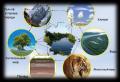
As I said before, there are many different elements in the natural world. I will list the main ones here:
- flora and fauna;
- climatic conditions;
- terrain;
- water;
- the soil.
A kind of vinaigrette from all of the above components forms a natural complex. There are many types and sizes of natural complexes. In general terms, a natural complex is a certain zone within which the interaction of natural components occurs, determined by laws.

The largest natural complex is the geographical envelope of the Earth. An example of a small natural complex would be a single lake or sea bay. A natural complex can be a mountain range or an entire ocean; it all depends on how broadly one is prepared to systematize the interaction of certain factors.

How a natural complex is formed
There are 2 groups of factors that influence the formation of natural complexes. The first group includes the so-called. zonal factors, that is, those that depend on the heating of the Earth by the Sun. They are also called external factors. Thanks to this group of factors, geographic zones and natural zones were formed.
The second group of factors includes azonal (internal) factors. These are the ones that pass inside the Earth itself. In short, I note that the result of such processes was the formation of the relief and general geological structure of the Earth. As an example of natural complexes formed by internal factors, I can cite the Cordillera, the Ural Mountains, the Alps and other mountainous regions.
Natural ingredients – components that form landscape complexes. The properties of the components, and some of them themselves, are largely derivatives of their interaction in the hardware and software. Main natural components of PTC: masses of rocks that make up the earth's crust (lithosphere); air masses of the lower layers of the atmosphere (troposphere); water (hydrosphere), presented in landscapes in three phase states (liquid, solid, vapor); vegetation, animals, soil. All natural components, according to their origin, properties and functions in landscapes, are combined into three subsystems:
1. Lithogenic base(geological rocks and relief); lower part of the atmosphere (troposphere air); hydrosphere (water) – geoma.
2. Biota- flora and fauna.
3. Soils– bioinert subsystem.
Sometimes relief and climate are called special components that have a great influence on the formation and properties of landscapes. However, they are only important properties of the earth's crust (lithogenic base) and surface air masses, which represent the external form and set of parameters and processes of the contact layers of the lithosphere, atmosphere and hydrosphere.
Properties of natural components:
1. Real(mechanical, physical, chemical composition).
2. Energy(temperature, potential and kinetic energy of gravity, pressure, biogenic energy, etc.).
3. Information and organizational(structure, spatial and temporal sequence, relative position and connections).
It is the properties of natural components that determine the specifics of the interaction of components within landscape geosystems. At the same time, they are derivatives of these interactions.
Natural components have a wide variety of properties, but they are far from equal in importance for the organization and development of territorial geosystems of geographical dimensions. The most active and important for a specific level of the PTC organization, the interacting properties of the components are called natural factors. Among the factors, there are leading ones, which are main for a certain level of organization of geosystems, and secondary ones, which determine the specifics of geosystems at other levels. They are one of the main reasons, driving forces that determine the results and types of interaction between natural components, as well as the structural and functional features of landscape geosystems (type of relief; climate, type of vegetation, etc.).
The influence of various factors on the properties of natural components in landscape complexes can be represented by the following examples.
The material composition of the Earth's surface layer (granites, basalts, clays, sands, water, ice) affects the albedo (reflectivity) of the surface and the nature of vegetation, which affects the temperature regime of the surface atmosphere. The temperature regime, which depends primarily on the radiation balance of the territory, also affects the vegetation cover and water regime in landscapes. The chemical composition of rocks and water masses, closely related to other natural components, for example, determines the geochemical and
species uniqueness of soils, vegetation and landscapes in general in different areas of land and oceans. Powerful and active landscape-forming factors can be gradients in matter and its properties between components (differences in temperature and heat capacity, differences in chemical composition, moisture, differences in the inertia of structures and processes - lithogenic base and vegetation; lithogenic base and air or water masses ). Due to the fact that each natural component is a special material substance, in the zone of their maximum and active contact, that is, on the surface of the Earth, significant gradients in the substance and its properties are observed. These gradients determine the formation and functioning of landscape complexes.
The main external energy factors that create the primary energy basis for the functioning of landscape geosystems are solar radiation, gravitational forces of the Earth and Moon, and intraterrestrial heat.
Among the factors, there are leading ones that have a major influence on the organization of geosystems of a certain rank and type, as well as secondary ones that determine the specifics of geosystems at other levels.
NATURAL COMPONENTS AS FACTORS DETERMINING THE SPECIFICITY OF LANDSCAPE GEOSYSTEMS
Lithogenic base landscape complexes, or geosystems, are the composition and structure of rocks, the relief of the earth's surface.
The lithogenic base, through the composition of rocks and relief, sets a rigid, very inertial framework for the natural complexes that form on it. In one natural zone, different vegetation forms on rocks of different mechanical composition. Thus, in the forest zone of the temperate zone, PTCs on clay and loamy rocks are characterized by spruce forests, and on sands - by the predominance of pine forests. If the clayey rocks in the southern taiga subzone are carbonated, then coniferous-deciduous forests develop here. Differences are also clearly expressed in desert landscapes formed on sandy, clayey and gravelly deposits.
Rocks of different mechanical and chemical composition determine differences in the ratios and volumes of surface and underground watercourses, ionic runoff, as well as differences in the soils formed on them (loamy, sandy loam, sandy, gravelly, carbonate, acidic, slightly alkaline, etc. ).
The presence of altitudinal zonation in the mountains and its change depending on the height and exposure of the slopes are known. By redistributing the water of atmospheric precipitation, the relief determines the moisture in natural complexes (all other things being equal). It is the difference in the reliefs of territories and the PTCs formed on them that determine the unequal potential and kinetic energy concentrated in the landscapes. This energy is realized, first of all, in the form of various erosion processes, as well as in the structural elements of the relief itself (the shape of the valleys, the dismemberment of the territory, etc.).
Different rocks form slopes of different steepness, and slopes of different steepness and their exposure absorb unequal amounts of heat. Warmer habitats are formed on the southern slopes, and colder ones are formed on the northern slopes (V.V. Alekhine’s preliminary rule). All this is reflected in the landscape features of the territory.
So, the lithogenic base is the most inert element of the landscape shell. Therefore, its basic properties are often the leading factors influencing the structural and functional organization of geosystems of a number of regional, and especially local, intra-landscape hierarchical levels of the PTC. This is manifested through the terrain features of the territories, the presence of surfaces with different slopes, hypsometry and exposure, which determine the redistribution of zonal-sector and local hydrothermal resources, the provision of plants with nutrients contained in different types of soils.
Atmosphere, or more precisely, air masses The lower, surface part of the troposphere is also included as a component in the composition and forms landscape complexes. Depending on the rank and type of landscape geosystems (local, regional), the thickness of the air mass included in the geosystems varies from tens to hundreds and a few thousand meters. The most important properties of air that influence the characteristics of other landscape components can be presented as follows.
The chemical composition of the air, namely the presence of carbon dioxide, is one of the basis for photosynthesis of green plants. Oxygen is necessary for breathing by all representatives of living nature, for the oxidation and mineralization of dead organic residues - mortmass. In addition, the presence of oxygen determines the formation of an ozone screen in the stratosphere, which protects proteinaceous life forms characteristic of the landscape shell from harmful ultraviolet radiation from the sun. At the same time, free oxygen in the atmosphere is itself a product of the photosynthesis process and is released by plants
in atmosphere. Nitrogen is an important component of proteins and, accordingly, one of the main elements of plant nutrition.
The air of the atmosphere, relatively transparent to the sun's rays of the visible spectrum, due to the presence of carbon dioxide and water vapor in it, well retains the infrared (thermal) radiation of the Earth. This ensures the “greenhouse effect”, that is, temperature fluctuations are smoothed out, and the heat of solar radiation lingers longer in landscapes.
Air currents in the atmosphere, transferring heat and moisture from one area to another, smooth out hydrothermal differences between landscapes. Air ensures heat and material exchange of substances between various components of geosystems. Thus, the air, enriched with dust raised from the earth’s surface, including salts, can transfer it to bodies of water, and the latter enrich the air with moisture, chlorine ions, sulfates, etc. They are transported to land by air currents. Moreover, wind flows are capable of forming meso- and microforms of relief (barchans, dunes, blowing depressions, etc.) and even determining the shape and character of plants (for example, flag-shaped, tumbleweeds).
If the lithosphere sets a rigid frame and is a very inertial component that defines hard and sharp boundaries in the spatial differentiation of landscapes, then air masses as a dynamic substance, on the contrary, integrate natural complexes, smoothing transitions between geosystems, and enhance the continuity of the landscape envelope.
Hydrosphere, or natural waters- an important part of landscapes. At temperatures prevailing in landscapes, water can exist in three phase states. The presence of more or less watered areas sharply differentiates the landscape envelope of the Earth into terrestrial (land) and aquatic geosystems (aquatic and territorial landscape complexes).
Water is one of the most heat-intensive substances on Earth (1 cal/g degree). In addition, it is characterized by very high costs of absorbed and released heat during phase transitions (ice, water, steam). This determines its main role in heat exchange between regions, as well as components and elements within geosystems. It is water, thanks to its properties, that forms many different-scale cycles of matter and energy, connecting different natural complexes and their components into single geosystems.
Surface runoff is a very powerful factor in the redistribution of matter between geosystems, as well as the formation of exogenous relief-20
pho- and lithogenesis. With water flows, the main types of exchange and migration of chemical elements occur both between landscape components and between landscape complexes, or geosystems, themselves. At the same time, waters with different acid-base properties are formed in different landscape conditions. The latter determine the different conditions of water migration and the concentration of various chemical elements in landscapes. So, A.I. Perelman proposed the following classification scheme of natural waters according to the characteristics of the migration of certain chemical elements into them (Table 2.1).
The concept of a natural complex
All shells of the Earth - lithosphere, hydrosphere, atmosphere, biosphere - are connected with each other. Plants cannot live without soil. If there are no plants, the gas composition of the atmosphere will change. Without water, all life on Earth will die. In nature, everything is closely connected with each other, forming a single whole. Within each shell, particles of other spheres can be distinguished. On the surface and in the depths of the lithosphere there are waters of the hydrosphere. Plants, animals, microorganisms live on the surface and at great depths in the earth's crust. The hydrosphere dissolves in itself individual substances of the lithosphere, carbon dioxide and atmospheric oxygen. In its entire thickness there are living organisms. Water vapor from the hydrosphere, dust particles from the lithosphere, and plant spores are found in the lower part of the atmosphere.
All living organisms in the biosphere are partially composed of water and minerals. When they die, they form sediments on the bottom of seas, oceans and continents.
The primary source of all processes of interaction between shells is the sun's rays. their energy, heating the earth's surface, causes the movement of air and water masses, the destruction of rocks, and gives life to organisms. The shell within which the upper layers of the earth's crust, the entire hydrosphere and the lower layers of the atmosphere collide, penetrate each other and interact is called geographic.
The word “complex” translated from Latin means connection, combination. A natural complex is a combination of components (components) of nature: rocks, water, air, organisms.
The most natural complex, covering the entire planet, is the geographical envelope. It is continuous, but not homogeneous. The difference in the angle of incidence of the sun's rays on the Earth's surface, the diversity of relief, vegetation and fauna, and the ratio of water and land determine the division of the geographical envelope into natural complexes of a lower order. The largest of them are continents and oceans, which are divided into smaller natural complexes - natural zones, natural areas, and the like.
All components of nature in a natural complex (NC) are closely interconnected and are in constant balance. A change in one of them leads to a change in the entire natural complex.
The interaction of relief and climate and their impact on soils, vegetation, and fauna
A natural zone is one of the largest natural complexes on Earth. The main factors in the formation of a natural zone are climate and relief, that is, the components of the natural complex on which the formation and development of its other components (soils, vegetation, fauna) depend. Natural zones are located throughout the landmass in a certain sequence from the Yusov Peninsula to the equator. their distribution can be traced on a map of natural areas of the world.
Arctic desert zone. In the circumpolar space the weather is constantly cold. Very low temperatures throughout the year make it impossible for vegetation to develop. Only mosses and lichens appear in small patches in summer on the islands of the Arctic Ocean and partly on the coast. Animals feed on organisms that live in the oxen of the ocean. Seagulls of various species, polar owls, polar bears, seals, arctic foxes are the main animals of the Arctic deserts. Gradually to the south this zone turns into the tundra zone.
The tundra occupies vast areas covered with swamps formed on the surface of permafrost. Tundra vegetation appears mainly in the Northern Hemisphere on the coast and islands of the Arctic Ocean and high in the mountains. There is almost none in the Southern Hemisphere, since there are no appropriate conditions for it here. The main feature of the zone is treelessness. Lichens and dwarf trees creeping along the ground (dwarf birch and polar willow) grow here. In summer there are a lot of berries (cranberries, cloudberries, lingonberries). There are a lot of mushrooms in autumn.
Tundra partridges, polar owls, small rodents - lemmings, large reindeer, arctic foxes and polar wolves inhabit this territory throughout the year. In winter, the tundra turns into desert. Herbivores feed on vegetation, which is preserved by snow cover; predators feed on herbivores.
In summer, many migratory birds (ducks, geese, seagulls) feed on fish and form columns on the steep sea cliffs - “bird colonies”.
Gradually to the south the tundra turns into forest-tundra. Trees (birch, spruce, larches) are already appearing here. The forest-tundra changes into taiga and a zone of mixed forests.
Taiga and mixed forests. Opals, more than in the tundra, winter and summer temperatures contribute to the spread of relatively rich woody vegetation. Coniferous trees (spruce, larch) grow here, and deciduous trees (birch, aspen) grow to the south. The undergrowth contains herbaceous and shrubby vegetation. Rich fauna. Hundreds of bird species, the largest of which are wood grouse and black grouse. Rodents include hares, squirrels, mice, etc. Hoofed herbivores include deer, roe deer, and moose, and predators include lynx, wolf, bear, sable, and marten. Man has greatly changed the nature of the taiga: he is cutting down large areas of forests, destroying birds and animals, and building cities and roads.
Mixed forests occupy the northern part of Ukraine, almost to the latitude of Kyiv.
The steppes stretch in a narrow strip across the entire territory of Eurasia and North America to the south of the forests. Distributed in the south of Ukraine. In summer, the climate in the steppe is hot and dry. There is little snow in winter. The vegetation in the steppe is herbaceous, since there is not enough moisture for the development of trees. The steppe, virgin to man, is especially beautiful in spring. Bright spots of irises and tulips, poppies, wild peonies and other flowers turn the steppe into a bright multi-colored carpet. By mid-summer the vegetation dries out and turns brown. The steppes have fertile soils - chernozems. Now the steppes are plowed. Natural flora and fauna are preserved only in nature reserves.
Desert. Of all the natural zones in the desert, the climate is the most arid and hot. The temperature in summer reaches 50 ° C, and the surface in some places (Sahara Desert) heats up to 80 ° C. There is not enough moisture, there is no continuous vegetation cover. Plants have adapted to such conditions. They have deep roots and thin, needle-like leaves (so that less moisture evaporates). Among the reptiles that live here are snakes and lizards, and rodents - jerboas. They escape from the scorching rays of the Sun in deep burrows and come to the surface at night. There are few birds.
Savannah. The closer to the equator, the more rain. In the savannah zone they fall in the summer. At this time, tall grasses completely cover the surface. Some of them, for example, elephant grass, reach a height of 5 m. Umbrella acacias grow in separate groups of trees, and baobabs grow in separate trees. During the dry season (winter), most trees shed their leaves and grasses dry out.
The savannas are home to many large ungulates, such as zebras, antelopes, giraffes, buffaloes, rhinoceroses, and elephants. Predators include lions, cheetahs, hyenas.
Man has significantly changed the nature of savannas. Wild animals are being deprived of their usual habitats. Untouched nature is preserved in nature reserves and national parks.
Wet equatorial forests. On both sides of the equator, where the climate is humid and hot, there is a zone of moist equatorial forests. Thousands of different types of trees, intertwined with vines, form impenetrable thickets. Through the dense vegetation of the equatorial forest there is a constant twilight. In a kilometer of area you can rarely find two identical trees.
It's constant summer here. Therefore, on one branch you can see both flowers and fruits at the same time. The animals and birds of these forests have constant food. Most animals live in the treetops where there is plenty of sun.
There is constant noise from monkeys, parrots, and other birds in the upper part of the forest, reaching 80 m above the ground. Below it is quiet, dark, damp, and only occasionally the spotted body of a jaguar or other predator flashes by. There are crocodiles, hippos and other animals in the reservoirs.
Equatorial rainforests are the lungs of our planet, as they release a lot of oxygen into the atmosphere. their preservation is the task of all humanity.
Thus, natural areas change mainly from the poles to the equator depending on the latitude of the area. But there are exceptions.
The location of natural zones is influenced by the altitude of the area, the proximity of seas and oceans, the presence of warm and cold currents, and other reasons.
Changes in natural complexes under the influence of human economic activity
Under the influence of human economic activity in the process of performing socio-economic functions using appropriate technology, natural complexes change and an anthropogenic landscape is formed. In such a landscape, the microrelief, soil, flora and fauna have undergone significant changes. Characteristic elements of the anthropogenic landscape: lands, settlements, industrial buildings, transport routes, anthropogenic landforms (canals, cockroaches, etc.). According to the degree of variability and the nature of human impact, landscapes are distinguished as changed, disturbed and transformed. In the changed landscape, anthropogenic activities affected individual components. A landscape that has suffered from intense irrational economic impact (mudflows and landslides caused by human activity, destruction of forests and plowing of steep slopes, continuous development, etc.) is called disturbed. In the transformed landscape, the natural components and connections between them are purposefully changed, these changes are scientifically justified by a system of environmental and other measures.
According to socio-economic functions, the following main types of anthropogenic landscape are distinguished: urban (formed in the process of creation and functioning of cities), agricultural landscape, forestry, water management, industrial, residential and recreational.
Anthropogenic changes in relief associated with the development, settlement and economic transformation of the territory. Due to the intensification of industry and agriculture, the number of anthropogenic landforms (main and distribution canals, quarries for mining) is growing. Bulk landforms include cockroaches, "tailings dumps" of metallurgical enterprises, dumps of thermal power plants, embankments of highways and railways. Subsidence craters appear in places of underground mining, landslides, etc.
Anthropogenic climate changes have global and regional aspects. Changes in the Earth's climate are associated with an increase in the content of carbon dioxide, aerosols, sulfates and dust in the atmosphere, with the possible destruction of the ozone layer, as well as pollution of the World Ocean. Regional changes are caused by the transformation of the earth's surface, which leads to changes in its radiation regime and the corresponding climate. Cutting down or planting forests, plowing land, reclamation of agricultural land, construction of various structures, and creation of artificial reservoirs create new types of microclimate. Significant regional climate changes occur around reservoirs, during the construction of hydroelectric power stations, thermal power plants and forestry.
The direct impact of economic activities on water bodies includes hydraulic engineering construction, fishing, the flow of untreated wastewater into the reservoir, and the side effects include the application of fertilizers and pesticides to agricultural land and their washing into water bodies.
The following types of impact of economic activities on soils are distinguished: mechanical, chemical and biological. Mechanical impact is soil degradation due to insufficiently justified agricultural practices. Chemical impact is a decrease in soil fertility. Biological impact - increased removal of nutrients along with the harvest.
The concept of a natural complex
The main object of study of modern physical geography is the geographical shell of our planet as a complex material system. It is heterogeneous in both vertical and horizontal directions. In the horizontal, i.e. spatially, the geographic envelope is divided into separate natural complexes (synonyms: natural-territorial complexes, geosystems, geographic landscapes).
A natural complex is a territory that is homogeneous in origin, history of geological development and modern composition of specific natural components. It has a single geological foundation, the same type and amount of surface and groundwater, a uniform soil and vegetation cover and a single biocenosis (a combination of microorganisms and characteristic animals). In a natural complex, the interaction and metabolism between its components are also of the same type. The interaction of components ultimately leads to the formation of specific natural complexes.
The level of interaction of components within a natural complex is determined primarily by the amount and rhythms of solar energy (solar radiation). Knowing the quantitative expression of the energy potential of a natural complex and its rhythm, modern geographers can determine the annual productivity of its natural resources and the optimal timing of their renewability. This allows us to objectively predict the use of natural resources of natural-territorial complexes (NTC) in the interests of human economic activity.
Currently, most of the natural complexes of the Earth have been changed to one degree or another by man, or even re-created by him on a natural basis. For example, oases in the desert, reservoirs, agricultural plantations. Such natural complexes are called anthropogenic. According to their purpose, anthropogenic complexes can be industrial, agricultural, urban, etc. According to the degree of change by human economic activity - in comparison with the original natural state, they are divided into slightly changed, changed and strongly changed.
Natural complexes can be of different sizes - of different ranks, as scientists say. The largest natural complex is the geographical envelope of the Earth. Continents and oceans are natural complexes of the next rank. Within the continents, physical-geographical countries are distinguished - natural complexes of the third level. Such, for example, as the East European Plain, the Ural Mountains, the Amazon Lowland, the Sahara Desert and others. Well-known natural zones can serve as examples of natural complexes: tundra, taiga, temperate forests, steppes, deserts, etc. The smallest natural complexes (terrains, tracts, fauna) occupy limited territories. These are hilly ridges, individual hills, their slopes; or a low-lying river valley and its individual sections: bed, floodplain, above-floodplain terraces. It is interesting that the smaller the natural complex, the more homogeneous its natural conditions. However, even natural complexes of significant size retain the homogeneity of natural components and basic physical-geographical processes. Thus, the nature of Australia is not at all similar to the nature of North America, the Amazonian lowland is noticeably different from the Andes adjacent to the west, an experienced geographer-researcher will not confuse the Karakum (temperate zone deserts) with the Sahara (tropical deserts), etc.
Thus, the entire geographical envelope of our planet consists of a complex mosaic of natural complexes of different ranks. Natural complexes formed on land are now called natural-territorial complexes (NTC); formed in the ocean and other body of water (lake, river) - natural aquatic (NAC); natural-anthropogenic landscapes (NAL) are created by human economic activity on a natural basis.
Geographical envelope - the largest natural complex
The geographic envelope is a continuous and integral shell of the Earth, which includes, in a vertical section, the upper part of the earth's crust (lithosphere), the lower atmosphere, the entire hydrosphere and the entire biosphere of our planet. What unites, at first glance, the heterogeneous components of the natural environment into a single material system? It is within the geographic envelope that a continuous exchange of matter and energy occurs, a complex interaction between the indicated component shells of the Earth.
The boundaries of the geographical envelope are still not clearly defined. Scientists usually take the ozone screen in the atmosphere as its upper limit, beyond which life on our planet does not extend. The lower boundary is most often drawn in the lithosphere at depths of no more than 1000 m. This is the upper part of the earth’s crust, which was formed under the strong combined influence of the atmosphere, hydrosphere and living organisms. The entire thickness of the waters of the World Ocean is inhabited, therefore, if we talk about the lower boundary of the geographical envelope in the ocean, then it should be drawn along the ocean floor. In general, the geographic shell of our planet has a total thickness of about 30 km.
As we can see, the geographical envelope coincides in volume and territorially with the distribution of living organisms on Earth. However, there is still no single point of view regarding the relationship between the biosphere and the geographical envelope. Some scientists believe that the concepts of “geographical envelope” and “biosphere” are very close, even identical, and these terms are synonyms. Other researchers consider the biosphere only as a certain stage in the development of the geographic envelope. In this case, three stages are distinguished in the history of the development of the geographical envelope: prebiogenic, biogenic and anthropogenic (modern). The biosphere, according to this point of view, corresponds to the biogenic stage of the development of our planet. According to others, the terms “geographical envelope” and “biosphere” are not identical, since they reflect different qualitative essences. The concept of “biosphere” focuses on the active and determining role of living matter in the development of the geographical envelope.
Which point of view should you prefer? It should be borne in mind that the geographic envelope is characterized by a number of specific features. It is distinguished, first of all, by the great diversity of material composition and types of energy characteristic of all component shells - the lithosphere, atmosphere, hydrosphere and biosphere. Through general (global) cycles of matter and energy, they are united into an integral material system. To understand the patterns of development of this unified system is one of the most important tasks of modern geographical science.
Thus, the integrity of the geographical envelope is the most important pattern, on the knowledge of which the theory and practice of modern environmental management is based. Taking this pattern into account makes it possible to foresee possible changes in the nature of the Earth (a change in one of the components of the geographic envelope will necessarily cause a change in the others); give a geographical forecast of the possible results of human impact on nature; carry out a geographical examination of various projects related to the economic use of certain territories.
The geographic envelope is also characterized by another characteristic pattern - the rhythm of development, i.e. recurrence of certain phenomena over time. In the nature of the Earth, rhythms of different durations have been identified - daily and annual, intra-century and super-secular rhythms. The daily rhythm, as is known, is determined by the rotation of the Earth around its axis. The daily rhythm is manifested in changes in temperature, air pressure and humidity, cloudiness, and wind strength; in the phenomena of ebb and flow in the seas and oceans, the circulation of breezes, the processes of photosynthesis in plants, the daily biorhythms of animals and humans.
The annual rhythm is the result of the movement of the Earth in its orbit around the Sun. These are the change of seasons, changes in the intensity of soil formation and destruction of rocks, seasonal features in the development of vegetation and human economic activity. It is interesting that different landscapes of the planet have different daily and annual rhythms. Thus, the annual rhythm is best expressed in temperate latitudes and very weakly in the equatorial belt.
Of great practical interest is the study of longer rhythms: 11-12 years, 22-23 years, 80-90 years, 1850 years and longer, but, unfortunately, they are still less studied than the daily and annual rhythms.
Natural zones of the globe, their brief characteristics
The great Russian scientist V.V. At the end of the last century, Dokuchaev substantiated the planetary law of geographic zoning - a natural change in the components of nature and natural complexes when moving from the equator to the poles. Zoning is primarily due to the unequal (latitudinal) distribution of solar energy (radiation) over the Earth's surface, associated with the spherical shape of our planet, as well as different amounts of precipitation. Depending on the latitudinal ratio of heat and moisture, the law of geographic zonation is subject to weathering processes and exogenous relief-forming processes; zonal climate, surface waters of land and ocean, soil cover, vegetation and fauna.
The largest zonal divisions of the geographic envelope are geographic zones. They stretch, as a rule, in the latitudinal direction and, in essence, coincide with climatic zones. Geographic zones differ from each other in temperature characteristics, as well as in the general characteristics of atmospheric circulation. On land the following geographical zones are distinguished:
Equatorial - common to the northern and southern hemispheres; - subequatorial, tropical, subtropical and temperate - in each hemisphere; - subantarctic and Antarctic belts - in the southern hemisphere. Belts with similar names have been identified in the World Ocean. The zonality in the ocean is reflected in changes from the equator to the poles in the properties of surface waters (temperature, salinity, transparency, wave intensity, etc.), as well as in changes in the composition of flora and fauna.
Within geographic zones, natural zones are distinguished based on the ratio of heat and moisture. The names of the zones are given according to the type of vegetation that predominates in them. For example, in the subarctic zone these are tundra and forest-tundra zones; in the temperate zone - forest zones (taiga, mixed coniferous-deciduous and broad-leaved forests), zones of forest-steppes and steppes, semi-deserts and deserts.
1. When briefly characterizing the natural zones of the globe during the entrance exam, it is recommended to consider the main natural zones of the equatorial, subequatorial, tropical, subtropical, temperate, subarctic and arctic zones of the northern hemisphere in the direction from the equator to the North Pole: the zone of evergreen forests (gils), the savannah zone and light forests, zone of tropical deserts, zone of hard-leaved evergreen forests and shrubs (Mediterranean), zone of temperate deserts, zone of broad-leaved and coniferous-deciduous (mixed) forests, taiga zone, tundra zone, ice zone (arctic desert zone).
When characterizing natural areas, it is necessary to adhere to the following plan.
1. Name of the natural area.
2. Features of its geographical location.
3. Main features of climate.
4. Predominant soils.
5. Vegetation.
6. Animal world.
7. The nature of the use of natural resources of the zone by humans.
The applicant can collect factual material to answer the specified questions of the plan using the thematic maps of the “Teacher’s Atlas”, which is required in the list of manuals and maps for the entrance exam in geography at KSU. This is not only not prohibited, but is also required by the “General Instructions” for standard programs for entrance exams in geography to Russian universities.
However, the characteristics of natural areas should not be “standardized”. It should be borne in mind that due to the heterogeneity of the relief and the earth's surface, the proximity and distance from the ocean (and, consequently, the heterogeneity of moisture), the natural zones of various regions of the continents do not always have a latitudinal extent. Sometimes they have an almost meridional direction, for example, on the Atlantic coast of North America, the Pacific coast of Eurasia, and other places. The natural zones that stretch latitudinally across the entire continent are also heterogeneous. They are usually divided into three segments, corresponding to the central inland and two oceanic sectors. Latitudinal, or horizontal, zoning is best expressed on large plains, such as the East European or West Siberian plains.
In the mountainous regions of the Earth, latitudinal zonality gives way to altitudinal zonality of landscapes to a natural change of natural components and natural complexes with an ascent into the mountains from their foothills to the peaks. It is caused by climate change with altitude: C for every 100 m of rise and an increase in the amount of precipitation and a decrease in temperature by 0.6 to a certain altitude (up to 2-3 km). The change of belts in the mountains occurs in the same sequence as on the plains when moving from the equator to the poles. However, in the mountains there is a special belt of subalpine and alpine meadows, which is not found on the plains. The number of altitude zones depends on the height of the mountains and the characteristics of their geographical location. The higher the mountains and the closer they are located to the equator, the richer their range (set) of altitude zones. The range of altitude zones in the mountains is also determined by the location of the mountain system relative to the ocean. In the mountains located near the ocean, a set of forest belts predominates; Inland (arid) sectors of continents are characterized by treeless high-altitude zones.
Natural complex - part of an ecosystem with established relationships between its various components, limited by natural boundaries: watersheds, common for a given territory, the first regionally widespread layer of low-permeability rocks from the surface (aquitard) and the ground layer of the atmosphere. Natural complexes associated with large water arteries are divided into smaller ones, related to tributaries of various orders. Accordingly, natural complexes of the first, second, third, etc. are distinguished. orders of magnitude. Under undisturbed conditions, two neighboring natural complexes can be almost completely identical, but when man-made impacts occur, any changes in the components of the ecosystem will affect primarily within the natural complex where the source of disturbance is located. In urban agglomerations, natural complexes are the basic elements that form the natural component of the natural-technogenic geosystem. The choice of the order of the natural complex considered in each specific case depends primarily on the scale of the work. In particular, for the city of Moscow, when carrying out small-scale works (1:50000 and smaller), it is advisable to identify natural complexes confined to first-order tributaries of the river. Moscow (Setuni, Yauza, Skhodnya, etc.) More detailed studies require consideration of natural complexes of smaller orders as “basic” ones. For work carried out on a scale of 1:10000, it is optimal to consider natural complexes confined to tributaries of the second, third and (in some cases) fourth orders.
Territories of the natural complex - areas of the earth's surface outlined by urban planning boundaries, within which green spaces are preserved in relatively undisturbed conditions or partially restored. In Moscow, the territories of the natural complex include: urban and suburban forests and forest parks, parks, green areas for various purposes, water surfaces and river valleys.
It is necessary to distinguish between the concepts of “natural complex” and “territories of a natural complex”: natural complex - a natural scientific concept, a single element of an ecosystem, whereas territory of the natural complex - an urban planning concept that defines the purpose and status of individual territories within the city of Moscow.
The doctrine of the natural-territorial complex, geographical landscape
Alexander Humboldt pointed out that “nature is unity in plurality, the combination of diversity through form and mixture, is the concept of natural things and natural forces as the concept of a living whole.”
A.N. Krasnov in 1895 formed the idea of “geographical combinations of phenomena” or “geographical complexes” that should be dealt with by private geosciences.
The generally recognized founders of Russian landscape science are V.V. Dokuchaev and L.S. Berg.
Landscape science began to develop especially rapidly in the 1960s in connection with the demands of practice, the development of agriculture and forestry, and land inventory. Academicians S.V. devoted their articles and books to landscape science issues. Kalesnik, V.B. Sochava, I.P. Gerasimov, as well as physical geographers and landscape scientists N.A. Solntsev, A.G. Isachenko, D.L. Ardmand, and others.
In the works of K.G. Ramana, E.G. Kolomyets, V.N. Solntsev developed the concept of polystructural landscape space.
The most important areas of modern landscape science include anthropogenic, in which a person and the results of his economic activities are considered not only as an external factor that disturbs the landscape, but as an equal component of the PTC or natural-anthropogenic landscape.
On the theoretical basis of landscape science, new interdisciplinary directions are being formed that have significant integration significance for all geography (ecological geography, historical geography of landscapes, etc.)
Natural-territorial complex. TPK Groups
Natural-territorial complex(natural geosystem, geographic complex, natural landscape), a natural spatial combination of natural components that form integral systems at different levels (from the geographic envelope to the facies); one of the basic concepts of physical geography.
There is an exchange of substances and energy between individual natural territorial complexes and their components.
Groups of natural-territorial complexes :
1) global;
2) regional;
3) local.
Towards global PTC refers to the geographic envelope (some geographers include continents, oceans and physiographic zones).
TO regional– physical-geographical countries, regions and other azonal formations, as well as zonal – physical-geographical belts, zones and subzones.
Local PTCs, as a rule, are confined to meso- and microforms of relief (ravines, gullies, river valleys, etc.) or to their elements (slopes, peaks, etc.).
Systematics of natural-territorial complexes
Option 1:
a) physical-geographical zoning.
b) physical-geographical country.
c) physical-geographical region.
d) physical-geographical region.
The result of work on physical-geographical zoning is a map of the USSR on a scale of 1:8000000, and then a landscape map on a scale of 1:4000000.
Under physical-geographical country is understood as a part of the continent, formed on the basis of a large tectonic structure (shield, plate, platform, folded area) and the common tectonic regime in the Neogene-Quaternary time, characterized by a certain unity of relief (plains, plateaus, upland shields, mountains and highlands), microclimate and its structure of horizontal zoning and altitudinal zonation. Examples: Russian Plain, Ural Mountain Country, Sahara, Fennoscandia. On maps of the physical-geographical zoning of continents, 65-75, sometimes more, natural complexes are usually identified.
Physiographic region- part of a physical-geographical country, isolated mainly during the Neogene-Quaternary time under the influence of tectonic movements, marine transgressions, continental glaciations, with the same type of relief, climate and a peculiar manifestation of horizontal zoning and altitudinal zonation. Examples: Meshchera Lowland, Central Russian Upland.
Option 2:
Typological classification. Determination of PTC by similarity.
a) Classes of natural complexes (mountain and plain).
b) Types (according to zonal criterion)
c) Genera and species (by the nature of vegetation and some other characteristics).
Comparing the physical-geographical zoning and typological classification of PTC, one can notice that in the system of physical-geographical zoning, the higher the rank of PTC, the more unique it is, while with typological classification, on the contrary, the higher the rank, the less pronounced its individuality
Related posts:
 Deviance, deviant behavior
 Concept of a natural complex Describe a small natural complex taking into account all components
 Brief stages of space exploration
 Analytical review of the literature on the research problem Formulation of the literature review
 Rector of State Budgetary Educational Institution of Higher Professional Education, Moscow State Pedagogical University - Candidate of Pedagogical Sciences, Associate Professor, Honorary Worker of Public Education Igor Mikhailovich Remorenko


